
Portal:Geography
The Geography Portal

Geography (from Ancient Greek γεωγραφία geōgraphía; combining gê 'Earth' and gráphō 'write') is the study of the lands, features, inhabitants, and phenomena of Earth. Geography is an all-encompassing discipline that seeks an understanding of Earth and its human and natural complexities—not merely where objects are, but also how they have changed and come to be. While geography is specific to Earth, many concepts can be applied more broadly to other celestial bodies in the field of planetary science. Geography has been called "a bridge between natural science and social science disciplines."
Origins of many of the concepts in geography can be traced to Greek Eratosthenes of Cyrene, who may have coined the term "geographia" (c. 276 BC – c. 195/194 BC). The first recorded use of the word γεωγραφία was as the title of a book by Greek scholar Claudius Ptolemy (100 – 170 AD). This work created the so-called "Ptolemaic tradition" of geography, which included "Ptolemaic cartographic theory." However, the concepts of geography (such as cartography) date back to the earliest attempts to understand the world spatially, with the earliest example of an attempted world map dating to the 9th century BCE in ancient Babylon. The history of geography as a discipline spans cultures and millennia, being independently developed by multiple groups, and cross-pollinated by trade between these groups. The core concepts of geography consistent between all approaches are a focus on space, place, time, and scale.
Today, geography is an extremely broad discipline with multiple approaches and modalities. There have been multiple attempts to organize the discipline, including the four traditions of geography, and into branches. Techniques employed can generally be broken down into quantitative and qualitative approaches, with many studies taking mixed-methods approaches. Common techniques include cartography, remote sensing, interviews, and surveying. (Full article...)
 Featured article -
-

Ricketts Glen State Park is a Pennsylvania state park on 13,193 acres (5,280 ha) in Columbia, Luzerne, and Sullivan counties in Pennsylvania in the United States. Ricketts Glen is a National Natural Landmark known for its old-growth forest and 24 named waterfalls along Kitchen Creek, which flows down the Allegheny Front escarpment from the Allegheny Plateau to the Ridge-and-Valley Appalachians. The park is near the borough of Benton on Pennsylvania Route 118 and Pennsylvania Route 487, and is in five townships: Sugarloaf in Columbia County, Fairmount and Ross in Luzerne County, and Colley and Davidson in Sullivan County.
Ricketts Glen's land was once home to Native Americans. From 1822 to 1827, a turnpike was built along the course of PA 487 in what is now the park, where two squatters harvested cherry trees to make bed frames from about 1830 to 1860. The park's waterfalls were one of the main attractions for a hotel from 1873 to 1903; the park is named for the hotel's proprietor, R. Bruce Ricketts, who built the trail along the waterfalls. By the 1890s Ricketts owned or controlled over 80,000 acres (320 km2; 120 sq mi) and made his fortune clearcutting almost all of that land, including much of what is now the park; however he preserved about 2,000 acres (810 ha) of virgin forest in the creek's three glens. The sawmill was at the village of Ricketts, which was mostly north of the park. After his death in 1918, Ricketts' heirs began selling land to the state for Pennsylvania State Game Lands. (Full article...) -
Enceladus is the sixth-largest moon of Saturn and the 19th-largest in the Solar System. It is about 500 kilometers (310 miles) in diameter, about a tenth of that of Saturn's largest moon, Titan. It is mostly covered by fresh, clean ice, making it one of the most reflective bodies of the Solar System. Consequently, its surface temperature at noon reaches only −198 °C (75.1 K; −324.4 °F), far colder than a light-absorbing body would be. Despite its small size, Enceladus has a wide variety of surface features, ranging from old, heavily cratered regions to young, tectonically deformed terrain.
Enceladus was discovered on August 28, 1789, by William Herschel, but little was known about it until the two Voyager spacecrafts, Voyager 1 and Voyager 2, flew by Saturn in 1980 and 1981. In 2005, the spacecraft Cassini started multiple close flybys of Enceladus, revealing its surface and environment in greater detail. In particular, Cassini discovered water-rich plumes venting from the south polar region. Cryovolcanoes near the south pole shoot geyser-like jets of water vapor, molecular hydrogen, other volatiles, and solid material, including sodium chloride crystals and ice particles, into space, totaling about 200 kilograms (440 pounds) per second. More than 100 geysers have been identified. Some of the water vapor falls back as "snow"; the rest escapes and supplies most of the material making up Saturn's E ring. According to NASA scientists, the plumes are similar in composition to comets. In 2014, NASA reported that Cassini had found evidence for a large south polar subsurface ocean of liquid water with a thickness of around 10 km (6 mi). The existence of Enceladus' subsurface ocean has since been mathematically modelled and replicated. (Full article...) -
Shen Kuo (Chinese: 沈括; 1031–1095) or Shen Gua, courtesy name Cunzhong (存中) and pseudonym Mengqi (now usually given as Mengxi) Weng (夢溪翁), was a Chinese polymath, scientist, and statesman of the Song dynasty (960–1279). Shen was a master in many fields of study including mathematics, optics, and horology. In his career as a civil servant, he became a finance minister, governmental state inspector, head official for the Bureau of Astronomy in the Song court, Assistant Minister of Imperial Hospitality, and also served as an academic chancellor. At court his political allegiance was to the Reformist faction known as the New Policies Group, headed by Chancellor Wang Anshi (1021–1085).
In his Dream Pool Essays or Dream Torrent Essays (夢溪筆談; Mengxi Bitan) of 1088, Shen was the first to describe the magnetic needle compass, which would be used for navigation (first described in Europe by Alexander Neckam in 1187). Shen discovered the concept of true north in terms of magnetic declination towards the north pole, with experimentation of suspended magnetic needles and "the improved meridian determined by Shen's [astronomical] measurement of the distance between the pole star and true north". This was the decisive step in human history to make compasses more useful for navigation, and may have been a concept unknown in Europe for another four hundred years (evidence of German sundials made circa 1450 show markings similar to Chinese geomancers' compasses in regard to declination). (Full article...) -
Cherry Springs State Park is an 82-acre (33 ha)[a] Pennsylvania state park in Potter County, Pennsylvania, United States. The park was created from land within the Susquehannock State Forest, and is on Pennsylvania Route 44 in West Branch Township. Cherry Springs, named for a large stand of Black Cherry trees in the park, is atop the dissected Allegheny Plateau at an elevation of 2,300 feet (701 m). It is popular with astronomers and stargazers for having "some of the darkest night skies on the east coast" of the United States, and was chosen by the Pennsylvania Department of Conservation and Natural Resources (DCNR) and its Bureau of Parks as one of "25 Must-See Pennsylvania State Parks".
The earliest recorded inhabitants of the area were the Susquehannocks, followed by the Seneca nation, who hunted there. The first settlement within the park was a log tavern built in 1818 along a trail; the trail became a turnpike by 1834 and a hotel replaced the tavern in 1874, then burned in 1897. In the late 19th and early 20th centuries the old-growth forests were clearcut; the state forest was established in 1901 and contains second growth woodlands. "Cherry Springs Scenic Drive" was established in 1922, and the Civilian Conservation Corps built much of Cherry Springs State Park during the Great Depression, including a picnic pavilion listed on the National Register of Historic Places (NRHP). An annual "Woodsmen's Show" has been held in the park each August since 1952. (Full article...) -
The Jordan River is a 51.4-mile-long (82.7 km) river in the U.S. state of Utah. Regulated by pumps at its headwaters at Utah Lake, it flows northward through the Salt Lake Valley and empties into the Great Salt Lake. Four of Utah's six largest cities border the river: Salt Lake City, West Valley City, West Jordan, and Sandy. More than a million people live in the Jordan Subbasin, part of the Jordan River watershed that lies within Salt Lake and Utah counties. During the Pleistocene, the area was part of Lake Bonneville.
Members of the Desert Archaic Culture were the earliest known inhabitants of the region; an archaeological site found along the river dates back 3,000 years. Mormon pioneers led by Brigham Young were the first European American settlers, arriving in July 1847 and establishing farms and settlements along the river and its tributaries. The growing population, needing water for drinking, irrigation, and industrial use in an arid climate, dug ditches and canals, built dams, and installed pumps to create a highly regulated river. (Full article...) -

Alodia, also known as Alwa (Greek: Aρουα, Aroua; Arabic: علوة, ʿAlwa), was a medieval kingdom in what is now central and southern Sudan. Its capital was the city of Soba, located near modern-day Khartoum at the confluence of the Blue and White Nile rivers.
Founded sometime after the ancient Kingdom of Kush fell, around 350 AD, Alodia is first mentioned in historical records in 569. It was the last of the three Nubian kingdoms to convert to Christianity in 580, following Nobadia and Makuria. It possibly reached its peak during the 9th–12th centuries when records show that it exceeded its northern neighbor, Makuria, with which it maintained close dynastic ties, in size, military power and economic prosperity. Being a large, multicultural state, Alodia was administered by a powerful king and provincial governors appointed by him. The capital Soba, described as a town of "extensive dwellings and churches full of gold and gardens", prospered as a trading hub. Goods arrived from Makuria, the Middle East, western Africa, India and even China. Literacy in both Nubian and Greek flourished. (Full article...) -
Black Moshannon State Park is a 3,480-acre (1,410 ha) Pennsylvania state park in Rush Township, Centre County, Pennsylvania, United States. It surrounds Black Moshannon Lake, formed by a dam on Black Moshannon Creek, which has given its name to the lake and park. The park is just west of the Allegheny Front, 9 miles (14 km) east of Philipsburg on Pennsylvania Route 504, and is largely surrounded by Moshannon State Forest. A bog in the park provides a habitat for diverse wildlife not common in other areas of the state, such as carnivorous plants, orchids, and species normally found farther north. As home to the "largest reconstituted bog in Pennsylvania", it was chosen by the Pennsylvania Department of Conservation and Natural Resources for its "25 Must-see Pennsylvania State Parks" list.
Humans have long used the Black Moshannon area for recreational, industrial, and subsistence purposes. The Seneca tribe used it as hunting and fishing grounds. European settlers cleared some land for farming, then clear-cut the vast stands of old-growth white pine and eastern hemlock. Black Moshannon State Park rose from the ashes of a depleted forest which had been largely destroyed by wildfire in the years following the lumber era. The forests were rehabilitated by the Civilian Conservation Corps during the Great Depression in the 1930s. Many of the buildings built by the Civilian Conservation Corps stand in the park today and are protected on the list of National Register of Historic Places in three historic districts. (Full article...) -

The expedition ship RRS Discovery in the Antarctic alongside the Great Ice Barrier, now known as the Ross Ice Shelf
The Discovery Expedition of 1901–1904, known officially as the British National Antarctic Expedition, was the first official British exploration of the Antarctic regions since the voyage of James Clark Ross sixty years earlier (1839–1843). Organized on a large scale under a joint committee of the Royal Society and the Royal Geographical Society (RGS), the new expedition carried out scientific research and geographical exploration in what was then largely an untouched continent. It launched the Antarctic careers of many who would become leading figures in the Heroic Age of Antarctic Exploration, including Robert Falcon Scott who led the expedition, Ernest Shackleton, Edward Wilson, Frank Wild, Tom Crean and William Lashly.
Its scientific results covered extensive ground in biology, zoology, geology, meteorology and magnetism. The expedition discovered the existence of the only snow-free Antarctic valleys, which contains the longest river of Antarctica. Further achievements included the discoveries of the Cape Crozier emperor penguin colony, King Edward VII Land, and the Polar Plateau (via the western mountains route) on which the South Pole is located. The expedition tried to reach the South Pole travelling as far as the Farthest South mark at a reported 82°17′S. (Full article...) -

Japan is an island country in East Asia. It is in the northwest Pacific Ocean and is bordered on the west by the Sea of Japan, extending from the Sea of Okhotsk in the north toward the East China Sea, Philippine Sea, and Taiwan in the south. Japan is a part of the Ring of Fire, and spans an archipelago of 14,125 islands, with the five main islands being Hokkaido, Honshu (the "mainland"), Shikoku, Kyushu, and Okinawa. Tokyo is the country's capital and largest city, followed by Yokohama, Osaka, Nagoya, Sapporo, Fukuoka, Kobe, and Kyoto.
The Japanese archipelago has been inhabited since the Upper Paleolithic (30,000 BC). Between the fourth and ninth centuries AD, the kingdoms of the region became unified under an emperor and the imperial court based in Heian-kyō. Beginning in the 12th century, political power was held by a series of military dictators (shōgun) and feudal lords (daimyō), and enforced by a class of warrior nobility (samurai). After a century-long period of civil war, the country was reunified in 1603 under the Tokugawa shogunate, which enacted an isolationist foreign policy. In 1854, a United States fleet forced Japan to open trade to the West, which led to the end of the shogunate and the restoration of imperial power in 1868. In the Meiji period, the Empire of Japan adopted a Western-modeled constitution, and pursued a program of industrialization and modernization. Amidst a rise in militarism and overseas colonization, Japan invaded China in 1937 and entered World War II as an Axis power in 1941. After suffering defeat in the Pacific War and two atomic bombings, Japan surrendered in 1945 and came under a seven-year Allied occupation, during which it adopted a new constitution. (Full article...) -

Winnipeg (/ˈwɪnɪpɛɡ/ ⓘ) is the capital and largest city of the province of Manitoba in Canada. It is centred on the confluence of the Red and Assiniboine rivers, near the longitudinal centre of North America. , Winnipeg had a city population of 749,607 and a metropolitan population of 834,678, making it Canada's sixth-largest city and eighth-largest metropolitan area.
The city is named after the nearby Lake Winnipeg; the name comes from the Western Cree words for "muddy water" – winipīhk. The region was a trading centre for Indigenous peoples long before the arrival of Europeans; it is the traditional territory of the Anishinabe (Ojibway), Ininew (Cree), Oji-Cree, Dene, and Dakota, and is the birthplace of the Métis Nation. French traders built the first fort, Fort Rouge, on the site in 1738. A settlement was later founded by the Selkirk settlers of the Red River Colony in 1812, the nucleus of which was incorporated as the City of Winnipeg in 1873. Being far inland, the city's climate is extremely seasonal (continental) even by Canadian standards, with average January highs of around −11 °C (12 °F) and average July highs of 26 °C (79 °F). (Full article...) -
SMS Kurfürst Friedrich Wilhelm ("His Majesty's Ship Prince-elector Friedrich Wilhelm") was one of the first ocean-going battleships of the German Kaiserliche Marine (Imperial Navy). The ship was named for Prince-elector (Kurfürst) Friedrich Wilhelm, 17th-century Duke of Prussia and Margrave of Brandenburg. She was the fourth pre-dreadnought of the Brandenburg class, along with her sister ships Brandenburg, Weissenburg, and Wörth. She was laid down in 1890 in the Imperial Dockyard in Wilhelmshaven, launched in 1891, and completed in 1893. The Brandenburg-class battleships carried six large-caliber guns in three twin turrets, as opposed to four guns in two turrets, as was the standard in other navies.
Kurfürst Friedrich Wilhelm served as the flagship of the Imperial fleet from her commissioning in 1894 until 1900. She saw limited active duty during her service career with the German fleet due to the relatively peaceful nature of the late 19th and early 20th centuries. As a result, her career focused on training exercises and goodwill visits to foreign ports. These training maneuvers were nevertheless very important to developing German naval tactical doctrine in the two decades before World War I, especially under the direction of Alfred von Tirpitz. She, along with her three sisters, saw only one major overseas deployment, to China in 1900–1901, during the Boxer Uprising. The ship underwent a major modernization in 1904–1905. (Full article...) -
Weymouth (/ˈweɪməθ/ WAY-məth) is a sea-side town and civil parish in the Dorset district, in the ceremonial county of Dorset, on the English Channel coast of England. Situated on a sheltered bay at the mouth of the River Wey, 11 km (7 mi) south of the county town of Dorchester, Weymouth had a population of 53,427 in 2021. It is the third-largest settlement in Dorset after Bournemouth and Poole. The greater Weymouth urban area has a population of 72,802.
The history of the town stretches back to the 12th century and includes roles in the spread of the Black Death, the settlement of the Americas and the development of Georgian architecture. It was a major departure point for the Normandy Landings during World War II. Prior to local government reorganisation in April 2019, Weymouth formed a borough with the neighbouring Isle of Portland. Since then the area has been governed by Dorset Council. Weymouth, Portland and the Purbeck district are in the South Dorset parliamentary constituency. (Full article...) -

Dorset (/ˈdɔːrsɪt/ DOR-sit; archaically: Dorsetshire /ˈdɔːrsɪt.ʃɪər, -ʃər/ DOR-sit-sheer, -shər) is a ceremonial county in South West England. It is bordered by Somerset to the north-west, Wiltshire to the north and the north-east, Hampshire to the east, the Isle of Wight across the Solent to the south-east, the English Channel to the south, and Devon to the west. The largest settlement is Bournemouth, and the county town is Dorchester.
The county has an area of 2,653 km2 (1,024 sq mi) and a population of 772,268. Around half of the population lives in the South East Dorset conurbation, which contains three of the county's largest settlements: Bournemouth (183,491), Poole (151,500), and Christchurch (31,372). The remainder of the county is largely rural, and its principal towns are Weymouth (53,427) and Dorchester (21,366). Dorset contains two unitary authority areas: Bournemouth, Christchurch and Poole, and Dorset. The county did not historically include Bournemouth and Christchurch, which were part of Hampshire. (Full article...) -
The Mount Cayley volcanic field (MCVF) is a remote volcanic zone on the South Coast of British Columbia, Canada, stretching 31 km (19 mi) from the Pemberton Icefield to the Squamish River. It forms a segment of the Garibaldi Volcanic Belt, the Canadian portion of the Cascade Volcanic Arc, which extends from Northern California to southwestern British Columbia. Most of the MCVF volcanoes were formed during periods of volcanism under sheets of glacial ice throughout the last glacial period. These subglacial eruptions formed steep, flat-topped volcanoes and subglacial lava domes, most of which have been entirely exposed by deglaciation. However, at least two volcanoes predate the last glacial period and both are highly eroded. The field gets its name from Mount Cayley, a volcanic peak located at the southern end of the Powder Mountain Icefield. This icefield covers much of the central portion of the volcanic field and is one of the several glacial fields in the Pacific Ranges of the Coast Mountains.
Eruptions along the length of the MCVF began between 1.6 and 5.3 million years ago. At least 23 eruptions have occurred throughout its eruptive history. This volcanic activity ranged from effusive to explosive, with magma compositions ranging from basaltic to rhyolitic. Because the MCVF has a high elevation and consists of a cluster of mostly high altitude, non-overlapping volcanoes, subglacial activity is likely to have occurred under less than 800 m (2,600 ft) of glacial ice. The style of this glaciation promoted meltwater escape during eruptions. The steep profile of the volcanic field and its subglacial landforms support this hypothesis. As a result, volcanic features in the MCVF that interacted with glacial ice lack rocks that display evidence of abundant water during eruption, such as hyaloclastite and pillow lava. (Full article...) -
The Tang dynasty (/tɑːŋ/, [tʰǎŋ]; Chinese: 唐朝), or the Tang Empire, was an imperial dynasty of China that ruled from 618 to 907, with an interregnum between 690 and 705. It was preceded by the Sui dynasty and followed by the Five Dynasties and Ten Kingdoms period. Historians generally regard the Tang as a high point in Chinese civilization, and a golden age of cosmopolitan culture. Tang territory, acquired through the military campaigns of its early rulers, rivaled that of the Han dynasty.
The Li family founded the dynasty after taking advantage of a period of Sui decline and precipitating their final collapse, in turn inaugurating a period of progress and stability in the first half of the dynasty's rule. The dynasty was formally interrupted during 690–705 when Empress Wu Zetian seized the throne, proclaiming the Wu Zhou dynasty and becoming the only legitimate Chinese empress regnant. The devastating An Lushan Rebellion (755–763) shook the nation and led to the decline of central authority in the dynasty's latter half. Like the previous Sui dynasty, the Tang maintained a civil-service system by recruiting scholar-officials through standardized examinations and recommendations to office. The rise of regional military governors known as jiedushi during the 9th century undermined this civil order. The dynasty and central government went into decline by the latter half of the 9th century; agrarian rebellions resulted in mass population loss and displacement, widespread poverty, and further government dysfunction that ultimately ended the dynasty in 907. (Full article...)


.jpg)


.png)
.jpg)


.png)


 Vital article
.jpg)
Other vital articles
|
|---|
Related portals
Get involved
 |
Here are some tasks awaiting attention:
|
Selected pictures
-
 Credit: Martin WaldseemüllerThe Waldseemüller map is a map drawn by German cartographer Martin Waldseemüller originally published in April 1507. It was one of the first maps to chart latitude and longitude precisely, the first map to use the name "America", and the first to depict the Americas as separate from Asia.
 -
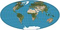 Map: Strebe, using GeocartThe Aitoff projection is a modified azimuthal map projection first proposed by David A. Aitoff in 1889. Based on the equatorial form of the azimuthal equidistant projection, Aitoff halved longitudes from the central meridian, projected by the azimuthal equidistant, and then stretched the result horizontally into a 2:1 ellipse.
 -
 Map credit: Robert WilkinsonAn 18th century map of the Iberian Peninsula illustrating various topographic features of the land. The Iberian Peninsula, or Iberia, is located in the extreme southwest of Europe, and includes modern day Spain, Portugal, Gibraltar and Andorra.
 -
 Map: Strebe, using GeocartThe General Perspective projection is a map projection used in cartography in which the Earth is depicted as viewed from a finite distance above its surface. If the view precisely faces the center of the Earth, the projection is a vertical perspective projection; otherwise, it is a tilted perspective projection. Here is shown a vertical perspective from an altitude of 35,786 km over (0°, 90°W), corresponding to a view from geostationary orbit. Due to the horizon as seen from the viewpoint position, the projection always shows less than half of the Earth's surface: in this case neither of the North and South Poles is visible.
 -
 Map: William C. Woodbridge; Restoration: Jujutacular and Lise BroerAn isothermal map of the world, based on the research of Alexander von Humboldt, a German naturalist whose work laid the foundation for the sciences of physical geography and meteorology, among other things. By delineating "isothermal lines", he simultaneously suggested the idea and devised the means of comparing the climatic conditions of various countries.
 -
 A world map entitled Nova totius terrarum orbis tabula Amstelodami, created in 1689 by Gerard van Schagen. This map, created in Amsterdam, measures 48.3 by 56.0 centimetres (19.0 by 22.0 in) in size and was made using copper engraving.
 -
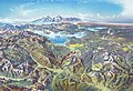 Map credit: Heinrich C. BerannYellowstone National Park is an American national park located mostly in Wyoming and extending into Montana and Idaho. It was established by the U.S. Congress and signed into law by President Ulysses S. Grant on March 1, 1872. Yellowstone was the first national park in the U.S. and is also widely held to be the first national park in the world. The park is known for its wildlife and its many geothermal features, especially the Old Faithful geyser, one of its most popular landmarks. It has many types of ecosystems, but the subalpine forest is the most abundant. The park is part of the South Central Rockies forests ecoregion. In 1978, Yellowstone was named a World Heritage Site by UNESCO.
This picture is a stylized panoramic map of Yellowstone National Park as viewed from the northeast, created in 1991 by Austrian painter and cartographer Heinrich C. Berann for the National Park Service. Yellowstone Lake and the Grand Canyon of the Yellowstone are in the center, while Old Faithful is visible on the right, next to a brown building representing the Old Faithful Inn. Jackson Lake and the peaks of the Teton Range are depicted in the background. -
 Daedongyeojido is a large scale map of Korea produced by Chosun Dynasty cartographer and geologist Kim Jeong-ho in 1861. Considered to mark the zenith of pre-modern Korean cartography, the map consists of 22 separate, foldable booklets, each covering approximately 47 kilometres (29 mi) (north-south) by 31.5 kilometres (19.6 mi) (east-west). Combined, they form a map of Korea that is 6.7 metres (22 ft) wide and 3.8 metres (12 ft) long. Daedongyeojido is praised for precise delineations of mountain ridges, waterways, and transportation routes, as well as its markings for settlements, administrative areas, and cultural sites.
 -
 Map credit: Fernão Vaz DouradoA pre-Mercator nautical chart of West Africa from 1571, by Portuguese cartographer Fernão Vaz Dourado. It is done using the so-called "plane chart model", where observed latitudes and magnetic directions were plotted directly into the plane, with a constant scale, as if the Earth were flat.
 -
 A detailed eighteenth-century map of Scandinavia by J. B. Homann, depicting Denmark, Norway, Sweden, Finland and the Baltic states of Livonia, Latvia and Curlandia. The map notes fortified cities, villages, roads, bridges, forests, castles and topography. The elaborate title cartouche in the upper left quadrant features angels supporting a title curtain and a medallion supporting an alternative title in French, "Les Trois Covronnes du Nord".
Born in 1664, Homann became an engraver and cartographer in the late 17th century, and opened his own publishing house in 1702. In 1715 Emperor Charles VI appointed him Imperial Geographer of the Holy Roman Empire. Homann held the position until his death in 1724. -
 Photo credit: Joaquim Alves GasparIllustration of the Ptolemaic geocentric model of the Universe (the theory that the Earth is the center of the universe) by Portuguese cosmographer and cartographer Bartolomeu Velho. Taken from his treatise Cosmographia, made in Paris, 1568. Notice the distances of the bodies to the centre of the Earth (left) and the times of revolution, in years (right).
 -
 Map: Strebe, using GeocartThe Chamberlin trimetric projection is a map projection where three points are fixed on the globe and the points on the sphere are mapped onto a plane by triangulation. It was developed in 1946 by Wellman Chamberlin for the National Geographic Society. It is neither conformal nor equal-area, but rather attempts to minimize distortion of distances everywhere with the side-effect of balancing between areal equivalence and conformality.
 -
 Map: Strebe, using GeocartThe Tobler hyperelliptical projection is a family of equal-area pseudocylindrical map projections first described by Waldo R. Tobler in 1973. The imagery used for the map is derived from NASA's Blue Marble summer months composite, with oceans lightened to enhance legibility and contrast.
 -
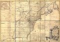 Author: John Mitchell; scan: Library of Congress, Geography and Map Division.The Mitchell Map is the most comprehensive map of eastern North America made during the colonial era. Measuring about 6.5 ft (2.0 m) wide by 4.5 ft (1.4 m) high, it was produced by John Mitchell in 1757 in eight separate sheets. The map was used during the Treaty of Paris for defining the boundaries of the United States, and remains important today for resolving border disputes.
 -
 Photo credit: Luca GaluzziThe north face of Mount Everest, as seen from Tibet. Everest is the highest mountain on Earth, as measured by the height of its summit above sea level, which is 8,848 metres (29,029 ft). In 1865, Everest was given its official English name by the Royal Geographical Society upon recommendation of Andrew Waugh, the British Surveyor General of India at the time.


Featured biography

Emery Molyneux (/ˈɛməri ˈmɒlɪnoʊ/ EM-ər-ee MOL-in-oh; died June 1598) was an English Elizabethan maker of globes, mathematical instruments and ordnance. His terrestrial and celestial globes, first published in 1592, were the first to be made in England and the first to be made by an Englishman.
Molyneux was known as a mathematician and maker of mathematical instruments such as compasses and hourglasses. He became acquainted with many prominent men of the day, including the writer Richard Hakluyt and the mathematicians Robert Hues and Edward Wright. He also knew the explorers Thomas Cavendish, Francis Drake, Walter Raleigh and John Davis. Davis probably introduced Molyneux to his own patron, the London merchant William Sanderson, who largely financed the construction of the globes. When completed, the globes were presented to Elizabeth I. Larger globes were acquired by royalty, noblemen and academic institutions, while smaller ones were purchased as practical navigation aids for sailors and students. The globes were the first to be made in such a way that they were unaffected by the humidity at sea, and they came into general use on ships. (Full article...)More featured biographies
|
|---|
Did you know
- ... that Johann Reinhold Forster's 1778 book Observations Made During a Voyage Round the World has been described as "the beginning of modern geography"?
- ... that glaciation in Wisconsin 17 thousand years ago helped create its unique geography?
Places around you
Top 10 WikiProject Geography Popular articles of the month
-

A map of the United States showing its 50 states, federal district and five inhabited territories. Alaska, Hawaii, and the territories are shown at different scales, and the Aleutian Islands and the uninhabited northwestern Hawaiian Islands are omitted from this map.
The United States of America is a federal republic consisting of 50 states, a federal district (Washington, D.C., the capital city of the United States), five major territories, and various minor islands. Both the states and the United States as a whole are each sovereign jurisdictions. The Tenth Amendment to the United States Constitution allows states to exercise all powers of government not delegated to the federal government. Each state has its own constitution and government, and all states and their residents are represented in the federal Congress, a bicameral legislature consisting of the Senate and the House of Representatives. Each state is represented by two senators, while representatives are distributed among the states in proportion to the most recent constitutionally mandated decennial census. Additionally, each state is entitled to select a number of electors to vote in the Electoral College, the body that elects the president of the United States, equal to the total of representatives and senators in Congress from that state. The federal district does not have representatives in the Senate, but has a non-voting delegate in the House, and it is also entitled to electors in the Electoral College. Congress can admit more states, but it cannot create a new state from territory of an existing state or merge two or more states into one without the consent of all states involved, and each new state is admitted on an equal footing with the existing states. (Full article...) -
Generation Z (often shortened to Gen Z), colloquially known as Zoomers, is the demographic cohort succeeding Millennials and preceding Generation Alpha. Researchers and popular media use the mid-to-late 1990s as starting birth years and the early 2010s as ending birth years. Most members of Generation Z are the children of Generation X or older Millennials. (Full article...)
-
Earth is the third planet from the Sun and the only astronomical object known to harbor life. This is enabled by Earth being a water world, the only one in the Solar System sustaining liquid surface water. Almost all of Earth's water is contained in its global ocean, covering 70.8% of Earth's crust. The remaining 29.2% of Earth's crust is land, most of which is located in the form of continental landmasses within Earth's land hemisphere. Most of Earth's land is somewhat humid and covered by vegetation, while large sheets of ice at Earth's polar deserts retain more water than Earth's groundwater, lakes, rivers and atmospheric water combined. Earth's crust consists of slowly moving tectonic plates, which interact to produce mountain ranges, volcanoes, and earthquakes. Earth has a liquid outer core that generates a magnetosphere capable of deflecting most of the destructive solar winds and cosmic radiation. (Full article...) -

Google Maps is a web mapping platform and consumer application offered by Google. It offers satellite imagery, aerial photography, street maps, 360° interactive panoramic views of streets (Street View), real-time traffic conditions, and route planning for traveling by foot, car, bike, air (in beta) and public transportation. , Google Maps was being used by over one billion people every month around the world. (Full article...) -
Millennials, also known as Generation Y (often shortened to Gen Y), are the demographic cohort following Generation X and preceding Generation Z. Researchers and popular media use the early 1980s as starting birth years and the mid-1990s to early 2000s as ending birth years, with the generation typically being defined as people born from 1981 to 1996. Most Millennials are the children of Baby Boomers and older Generation X. In turn Millennials are often the parents of Generation Alpha. (Full article...)
-

Hong Kong is a special administrative region of the People's Republic of China. With 7.4 million residents of various nationalities in a 1,104-square-kilometre (426 sq mi) territory, Hong Kong is one of the most densely populated territories in the world. (Full article...) -
Generation X (often shortened to Gen X) is the demographic cohort following the Baby Boomers and preceding Millennials. Researchers and popular media often use the mid-1960s as its starting birth years and the late 1970s as its ending birth years, with the generation being generally defined as people born from 1965 to 1980. By this definition and U.S. Census data, there are 65.2 million Gen Xers in the United States as of 2019. Most of Generation X are the children of the Silent Generation and early Baby Boomers; Xers are also often the parents of Millennials and Generation Z. (Full article...)
-
London is the capital and largest city of both England and the United Kingdom, with a population of around 8.8 million, and its metropolitan area is the largest in Western Europe, with a population of 14.9 million. It stands on the River Thames in south-east England at the head of a 50-mile (80 km) estuary down to the North Sea and has been a major settlement for nearly two millennia. The City of London, its ancient core and financial centre, was founded by the Romans as Londinium and retains its medieval boundaries. The City of Westminster, to the west of the City of London, has for centuries hosted the national government and parliament. In the 19th century, London grew rapidly, becoming the world's largest city at the time, as it expanded and absorbed the neighbouring county of Middlesex, and parts of Surrey and Kent. In 1965 it was combined with parts of Essex and Hertfordshire to create the administrative area of Greater London, which is governed by 33 local authorities and the Greater London Authority. (Full article...) -

England is a country that is part of the United Kingdom. The country is located on the island of Great Britain, of which it covers roughly 62%, and over 100 smaller adjacent islands. It has land borders with Scotland to the north and Wales to the west, and is otherwise surrounded by the North Sea to the east, the English Channel to the south, the Celtic Sea to the south-west, and the Irish sea to the west. Continental Europe lies to the south-east, and Ireland to the west. The population was 56,490,048 at the 2021 census. London is both the largest city and the capital. (Full article...) -
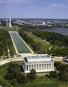
Washington, D.C., formally the District of Columbia and commonly called Washington or D.C., is the capital city and federal district of the United States. The city is on the Potomac River, across from Virginia, and shares land borders with Maryland to its north and east. Washington, D.C., was named for George Washington, a Founding Father and the first president of the United States. The district is named for Columbia, the female personification of the nation. (Full article...)

.jpg)

.jpeg)


Featured pictures


Main articles
 Categories
Associated Wikimedia
The following Wikimedia Foundation sister projects provide more on this subject:
-
 Commons
Free media repository -
 Wikibooks
Free textbooks and manuals -
 Wikidata
Free knowledge base -
 Wikinews
Free-content news -
 Wikiquote
Collection of quotations -
 Wikisource
Free-content library -
 Wikiversity
Free learning tools -
 Wikivoyage
Free travel guide -
 Wiktionary
Dictionary and thesaurus


