
Mount Tasman
| Mount Tasman | |
|---|---|
 | |
| Highest point | |
| Elevation | 3,497 m (11,473 ft) |
| Prominence | 519 m (1,703 ft) |
| Listing | New Zealand #2 |
| Coordinates | 43°34′S 170°9′E / 43.567°S 170.150°E |
| Naming | |
| Native name | Te Horokōau (Māori) |
| Geography | |
.png) Mount Tasman Location in New Zealand | |
| Parent range | Southern Alps |
| Climbing | |
| First ascent | February 1895 by Edward Fitzgerald, Matthias Zurbriggen und Jack Clarke |
| Easiest route | glacier/snow/ice climb |
Mount Tasman (Te Horokōau in Māori)[1][2] is New Zealand's second-highest mountain, rising to a height of 3,497 metres (11,473 ft). It is located in the Southern Alps of the South Island, four kilometres to the north of its larger neighbour, Aoraki / Mount Cook. Unlike Aoraki / Mount Cook, Mount Tasman sits on the South Island's Main Divide, on the border between Aoraki / Mount Cook National Park and Westland Tai Poutini National Park. It is the highest point in Westland District.[citation needed]
The first ascent of Mount Tasman was in 1895 by Edward FitzGerald and his guide Matthias Zurbriggen.[3]
The Māori name (horo: to swallow; koau: shag or Phalacrocorax varius) is believed to refer to the swelling in the neck of a shag when it is swallowing a fish.[4]
Aoraki / Mount Cook National Park
Mount Tasman is located in Aoraki / Mount Cook National Park in the Canterbury Region, which was established in 1953 and along with Westland Tai Poutini National Park, Mount Aspiring National Park and Fiordland National Park forms one of the UNESCO World Heritage Sites.[citation needed]
Gallery
-
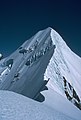 Mt Tasman north shoulder view south to summit, 21 March 1983
 -
 Mt Tasman peak looking SW from Mt Haidinger summit, 19 March 1983
 -
 Mt Haast, Mt Lendenfeld, Mt Tasman and Torres Peak NZ helicopter view from NW, Nov 28 2008
 -
 Mt Tasman helicopter view from SE above Grand Plateau, Nov 28 2008
 -
 Mt Tasman viewed from north at helicopter landing on Fox nevé, Nov 28 2008


See also
References
- ^ "Place name detail: Te Horokōau". New Zealand Gazetteer. New Zealand Geographic Board. Retrieved 16 November 2023.
- ^ "Useful Documents | District Plan Review Stage Three | Let's Talk | Kōrero Mai – Mackenzie". letstalk.mackenzie.govt.nz. p. 11. Retrieved 16 November 2023.
- ^ Wilson, John. "Mountaineering – Aoraki/Mt Cook". Te Ara: The Encyclopedia of New Zealand. Retrieved 5 December 2020.
- ^ Reed, A. W. (2010). Peter Dowling (ed.). Place Names of New Zealand. Rosedale, North Shore: Raupo. p. 391. ISBN 9780143204107.
| International | |
|---|---|
| National | |
This West Coast Region (New Zealand) geography article is a stub. You can help Wikipedia by expanding it. |
This Canterbury Region-related geography article is a stub. You can help Wikipedia by expanding it. |