
Maita Station (Kanagawa)
B13 Maita Station 蒔田駅 | |||||||||||
|---|---|---|---|---|---|---|---|---|---|---|---|
 Entrance No.3 | |||||||||||
| General information | |||||||||||
| Location | Miyamoto-chō 3-46, Minami, Yokohama, Kanagawa (横浜市南区宮元町三丁目46) Japan | ||||||||||
| Operated by | Yokohama City Transportation Bureau | ||||||||||
| Line(s) | |||||||||||
| Platforms | 2 side platforms | ||||||||||
| Tracks | 2 | ||||||||||
| Other information | |||||||||||
| Station code | B13 | ||||||||||
| History | |||||||||||
| Opened | 16 December 1972 | ||||||||||
| Passengers | |||||||||||
| 2008 | 11,315 daily | ||||||||||
| Services | |||||||||||
| |||||||||||
| |||||||||||


Maita Station (蒔田駅, Maita-eki) is an underground metro station located in Minami-ku, Yokohama, Kanagawa, Japan operated by the Yokohama Municipal Subway’s Blue Line (Line 1). It is 16.5 kilometers from the terminus of the Blue Line at Shōnandai Station.
Lines
Station layout
Maita Station is an underground station with two opposed side platforms serving two tracks.
Platforms
| 1 | ■ Blue Line (Yokohama) | Kamiōoka, Totsuka, Shōnandai |
| 2 | ■ Blue Line (Yokohama) | Kannai, Yokohama, Shin-Yokohama, Azamino |
-
 Ticket gates
 -
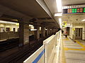 Platform


History
Maita Station was opened on 16 December 1972. Platform screen doors were installed in September of 2007.
References
- Harris, Ken and Clarke, Jackie. Jane's World Railways 2008-2009. Jane's Information Group (2008). ISBN 0-7106-2861-7
Wikimedia Commons has media related to Maita Station (Kanagawa).
External links
- Maita Station (Blue Line) (in Japanese)
35°25′48″N 139°36′36″E / 35.43000°N 139.61000°E
This Kanagawa Prefecture railroad station-related article is a stub. You can help Wikipedia by expanding it. |