
Longue Pointe
53°58′26.45″N 79°04′44.60″W / 53.9740139°N 79.0790556°W Longue Pointe (French for "Long Point") is a place located in northern Quebec, Canada. It is part of the Cree Nation of Chisasibi Category I Land (land for exclusive use by Cree) but has no permanent population. It is used by both Cree and Inuit natives as a harbour for their fishing boats.
It is among the furthest northern point reached by road in Quebec, extending from the James Bay Road (north of the Grand River). Only the Trans-Taiga Road extends farther to the north.
Location
Longue Pointe is about 25 kilometres (16 mi) north-west from Chisasibi on James Bay, and located on the border of Quebec and Nunavut Territory.[1] It is accessible by a 48 kilometres (30 mi) gravel road from Hydro-Québec's La Grande-1 generating station, on the Grand River. The area overlooks James Bay (about 85 kilometres (53 mi) south from where it joins Hudson Bay). Early European fur traders frequented these parts, around the start of the Hudson's Bay Company.
Image gallery
-
 La Grande-1 hydroelectric generating station
 -
 Sign showing distance to Longue Pointe
 -
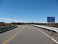
 A portion of Longue Pointe Road
 -
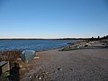
 Longue Pointe, on James Bay
 -
 Longue Pointe, on James Bay (with James Bay in background)
 -
 Canoe rentals at Longue Pointe
 -
 Canoe rental office at Longue Pointe
 -
 Cree homes, located along the Longue Pointe Road


External links
- Longe Pointe on Google Maps
- James Bay Road Website
- James Bay Hiking Trip
References
This Quebec location article is a stub. You can help Wikipedia by expanding it. |