
Keri (island)
 Keri island | |
 | |
| Geography | |
|---|---|
| Location | Gulf of Finland |
| Coordinates | 59°42′N 25°02′E / 59.700°N 25.033°E |
| Area | 3.1 ha (7.7 acres) |
| Administration | |
Estonia | |
| County | Harju County |
| Municipality | Viimsi Parish |
| Settlement | Kelnase village |
| Demographics | |
| Population | 0 |
Keri (Swedish: Kockskär, German: Kokskär) is a 3.1-hectare (7.7-acre) uninhabited Estonian island in the Gulf of Finland of the Baltic Sea. Keri is administratively part of Kelnase village, Viimsi Parish, Harju County. It is one of the northernmost islands of Estonia and the site of Keri Lighthouse, located about 6 km north of the nearest inhabited island of Prangli.
Keri lies by important sea routes and first written records of the island date from 1623. A wooden lighthouse building was erected on Keri in 1724, and the present-day lighthouse was built in 1803.[1]
In 1902, during a well drilling, natural gas was discovered in Keri. From 1906 to 1912 the gas was used to power the lighthouse and heat other buildings on the island. During that time it was the only lighthouse in the world to be powered by natural gas. In 1912, after a seismic impulse the gas flow stopped.[2]
Throughout the recent centuries Keri has for most of the time been inhabited only by the families of lighthouse keepers. The last keeper left the island in September 2002. Since then the lighthouse has been operating automatically; the necessary power has been generated by a wind turbine and solar panels.
During World War II, at the outset of the Soviet invasion and occupation of Estonia, on 14 June 1940, a Finnish civilian passenger airplane Kaleva (as Aero Flight 1631 from Tallinn to Helsinki) was shot down over the sea near Keri island by two Soviet military combat aircraft, killing all nine on board.[3] On 14 June 1993, a monument to commemorate the nine victims was erected on Keri. The wreck of Kaleva was found on 5 June 2024 by divers at the rough seabed in Estonian territorial waters near the island, at a depth of 71–76 meters.[4]
Gallery
-
 Keri lighthouse (2007)
 -
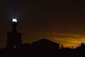 Keri lighthouse at night (2015)
 -
 Aerial view of former lighthouse keeper's house and Kaleva memorial
 -
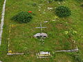 The Kaleva memorial
 -
 View towards Keri (near horizon) from neighbouring Prangli lighthouse


.JPG)


References
- ^ "Keri Island". Baltic Sea Now. Archived from the original on 7 June 2012. Retrieved 27 July 2012.
- ^ "Kelnase küla" (in Estonian). eestigiid.ee. Retrieved 27 July 2012.
- ^ Niku, Risto (2007). Kalevan kuolemanlento (in Finnish). Jyväskylä: Edita. p. 11. ISBN 978-951-37-4965-1.
- ^ "Itämeri | Matkustajalentokone Kaleva on löytynyt – oli kateissa yli 80 vuotta". Helsingin Sanomat (in Finnish). 2024-06-05. Retrieved 2024-06-05.
This Harju County location article is a stub. You can help Wikipedia by expanding it. |