
Keoti Fort
This article needs additional citations for verification. (January 2024) |
| Keoti Fort | |
|---|---|
| Part of Madhya Pradesh, | |
| Rewa District, Madhya Pradesh, India | |
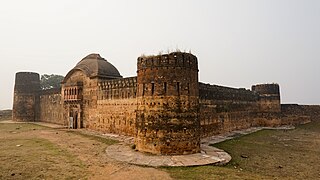
 Keoti Fort, front and south side, ca. 2024 | |
 Keoti Fort | |
| Coordinates | 24°49′02″N 81°27′26″E / 24.81714°N 81.45725°E |
| Type | Fort |
| Site information | |
| Open to the public | yes |
| Condition | dilapidated |
Keoti Fort (also Keonti Fort) is an Indian fortress (qila) situated on the Rewa Plateau about 53 kilometres (33 mi) north-east of the city of Rewa, in Rewa district in the Indian state of Madhya Pradesh.
History
Keoti Fort is mentioned in an account of the Indian Rebellion of 1857. Thakur Ranmat Sinha, a leader in the Rebellion in Rewa State, went into hiding near Keoti Fort. In an encounter at the fort, he killed a British officer who had come to arrest him. Eventually, he surrendered at the urging of the Maharaja Raghuraj Singh who supported the British. He was hanged in 1860 for the murder of the British officer.[1][2]
Geography
Keoti Fort is situated on the Rewa Plateau near the northern end of the Vindhya Escarpment.[3] The fort is built on the right bank of a ravine that the Mahana River has cut into the escarpment. The 98 m (322 ft) high Keoti Falls is on the opposite side of the ravine, visible from the northern part of the fort. The elevation of Keoti Fort is 280 m (920 ft) above mean sea level.[citation needed]
Keoti Fort is about 53 km (33 mi) from the city of Rewa.[4] The nearest airport is located at Prayagraj (Allahabad) in Uttar Pradesh, a distance of 114 km (71 mi).[5]
Architecture


The west wall of the fort runs along the Mahana ravine for about 200 m (660 ft). The south wall extends about 100 m (330 ft) east from the ravine. The east wall with the main entrance is about 40 m (130 ft) long. There after, the fort depth narrows to about 25 m (82 ft) at the northern end of the fort. The total area enclosed by the walls is about 1.0 ha (2.5 acres). Towers are located at the corners of the outer walls.[citation needed]
The construction material is stone and clay mortar. Loopholes with three angles of fire are built into the outer walls at regular intervals and at various heights. These are useful for defense against enemy coming across the flat plateau.[citation needed]
Tourism
The fort is open to the public. Entrance is free (January 2024).[citation needed]
Gallery
Exterior views
-
 Front (east) facade
 -
 Ornamental tiles in wall to left of the east entrance
 -
 Front and north side
 -
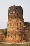 Tower on south-east corner
 -
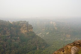 Gorge of the Mahana River behind the fort


Interior views
-
 Inside south-west part, tower overlooking the ravine, loopholes near the top of the wall
 -
 Northern inside of the fort: ravine on left, north wall in centre, east wall on right
 -
 Loophole in outer wall for firearms
 -
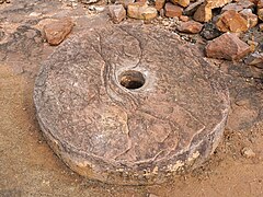 Grinding stone inside the fort


See also
References
- ^ "Thakur Ranmat Singh". Ministry of Culture (India). Archived from the original on 21 January 2024. Retrieved 21 January 2024.
- ^ Srivastava, A.C. (1961). "THAKUR RANMAT SINGH OF REWA [Summary]" (PDF). Proceedings of the Indian History Congress. 24. Indian History Congress: 224–225.
- ^ Hawkes, J.D. (25 March 2014). "One Size Does Not Fit All: Landscapes of Religious Change in Vindhya Pradesh". South Asian Studies. 30 (1). Routledge: 2–3.
- ^ "Rewa-Keoti Fort route". OpenStreetMap. Retrieved 21 January 2024.
- ^ "Prayagraj (Allahabad) Airport - Keoti Fort route". OpenStreetMap. Retrieved 21 January 2024.