
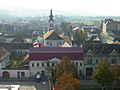
Dumbrăveni
Dumbrăveni | |
|---|---|
.JPG) Dumbrăveni Townhall | |
 Coat of arms | |
 Location in Sibiu County | |
 Dumbrăveni Location in Romania | |
| Coordinates: 46°13′39″N 24°34′33″E / 46.22750°N 24.57583°E | |
| Country | Romania |
| County | Sibiu |
| Government | |
| • Mayor (2020–2024) | Emil Dârloșan[1] (PSD) |
| Area | 55.75 km2 (21.53 sq mi) |
| Elevation | 495 m (1,624 ft) |
| Highest elevation | 600 m (2,000 ft) |
| Lowest elevation | 340 m (1,120 ft) |
| Population (2021-12-01)[2] | 6,238 |
| • Density | 110/km2 (290/sq mi) |
| Time zone | EET/EEST (UTC+2/+3) |
| Vehicle reg. | SB |
| Website | www |
Dumbrăveni (before 1945 Ibașfalău; German: Elisabethstadt; Saxon dialect: Eppeschdorf; Hungarian: Erzsébetváros) is a town in the north of Sibiu County, in the centre of Transylvania, central Romania. The town administers two villages, Ernea (Ehrgang; Argung; Szászernye) and Șaroș pe Târnave (Scharosch an der Kokel; Šuerš; Szászsáros).
Geography
Dumbrăveni lies on the banks of the river Târnava Mare, 20 km (12 mi) east from the city of Mediaș, the second largest city in the county, and 77 km (48 mi) northeast of Sibiu, the county seat. It is situated on the Transylvanian Plateau, on the border with Mureș County, midway between Mediaș and Sighișoara.[3]
The town is crossed on its southern edge by National Road DN14, which connects Sibiu to Sighișoara. There is also a train station that serves Line 300 of the CFR network, which connects Bucharest with the Hungarian border near Oradea.
The Șaroș gas field is located on the territory of Dumbrăveni.
Demographics
| Year | Pop. | ±% |
|---|---|---|
| 1910 | 4,408 | — |
| 1930 | 4,067 | −7.7% |
| 1948 | 4,562 | +12.2% |
| 1956 | 5,367 | +17.6% |
| 1966 | 8,452 | +57.5% |
| 1977 | 9,883 | +16.9% |
| 1992 | 9,354 | −5.4% |
| 2002 | 8,812 | −5.8% |
| 2011 | 6,990 | −20.7% |
| 2021 | 6,238 | −10.8% |
| Source: Census data | ||
At the 2021 Romanian census, Dumbrăveni had a population of 6,238. According to the 2011 census, 71.1% of inhabitants were Romanians, 18.4% Roma, 9.2% Hungarians, and 1% Germans (more specifically Transylvanian Saxons).
For Armenian Catholics, see Ordinariate for Armenian Catholics of Romania.
Natives
- Virgil Atanasiu (born 1937), sports shooter
- Árpád Szabó (1878–1948), Hungarian politician
Education
There are two secondary schools in this town: the Dumbrăveni Theoretical High School[4] and the Timotei Cipariu High School.[5]
See also
- Apafi Castle
- Armenian Catholic church of Dumbrăveni
- Dumbrăveni Prison
- Fortified church of Șaroș pe Târnave
- Roman Catholic church of Dumbrăveni
Gallery
-
 Timotei Cipariu High School in Dumbrăveni
 -
 Apafi Castle
 -
 Roman Catholic church
 -
 Armenian Catholic church in the main square of Dumbrăveni
 -
 Fortified church of Șaroș pe Târnave village
 -
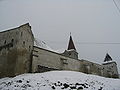 Medieval Evangelical Lutheran Transylvanian Saxon fortified church church of Șaroș pe Târnave in winter
 -
 The plan of the medieval Evangelical Lutheran Transylvanian Saxon fortified church of Șaroș pe Târnave
.JPG)
.JPG)
.JPG)


References
- ^ "Results of the 2020 local elections". Central Electoral Bureau. Retrieved 14 June 2021.
- ^ "Populaţia rezidentă după grupa de vârstă, pe județe și municipii, orașe, comune, la 1 decembrie 2021" (XLS). National Institute of Statistics.
- ^ "Istoria Orașului: Așezare". www.primariadumbraveni.ro (in Romanian). Dumbrăveni Townhall. Retrieved September 19, 2021.
- ^ Stafie, Costică (June 16, 2013). "Liceul Teoretic Dumbrăveni, un liceu cu o istorie de peste 100 de ani". Monitorul de Mediaș (in Romanian). Retrieved September 19, 2021.
- ^ "Liceul "Timotei Cipariu" Dumbrăveni". www.liceultimoteicipariu.ro (in Romanian). Retrieved September 19, 2021.

| International | |
|---|---|
| National | |
This Sibiu County location article is a stub. You can help Wikipedia by expanding it. |