
Bodega Ridge Provincial Park
| Bodega Ridge Provincial Park | |
|---|---|
 Saltspring and Vancouver Islands seen from Bodega Ridge | |
  Map of British Columbia | |
| Location | Cowichan Land District, British Columbia, Canada |
| Nearest city | Ladysmith, BC |
| Coordinates | 48°57′27″N 123°32′03″W / 48.95750°N 123.53417°W |
| Area | 397 ha. (3.97 km²) |
| Established | April 11, 2001 |
| Governing body | BC Parks |
Bodega Ridge Provincial Park is a provincial park in British Columbia, Canada. It is on Galiano Island, which lies between Vancouver and Vancouver Island, and comprises 233 hectares (580 acres). The park's high cliffs are home to bald eagles, peregrine falcons, and turkey vultures.[1]

The park was preserved as a result of a long fund-raising campaign from 1991 to 1995, which eventually gained the support of the Nature Conservancy of Canada. In recent years it has received donations from adjacent landowners, and has nearly doubled in size.
Gallery
-
 A hiker on Bodega Ridge
 -
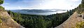 A panoramic view from the ridge
 -
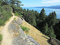 Hiking trail on Bodega Ridge
 -
 A map of Bodega Ridge Provincial Park, as enlarged by recent donations

.jpg)

References
- ^ "Bodega Ridge Park". BC Parks. Retrieved June 1, 2024.