
Fossa (planetary nomenclature)
This article contains too many pictures for its overall length. (June 2022) |
In planetary nomenclature, a fossa /ˈfɒsə/ (pl. fossae /ˈfɒsiː/) is a long, narrow depression (trough) on the surface of an extraterrestrial body, such as a planet or moon. The term, which means "ditch" or "trench" in Latin, is not a geological term as such but a descriptor term used by the United States Geological Survey (USGS) and the International Astronomical Union (IAU) for topographic features whose geology or geomorphology is uncertain due to lack of data or knowledge of the exact processes that formed them. Fossae are believed to be the result of a number of geological processes, such as faulting or subsidence. Many fossae on Mars are probably graben.
On Mars
The Tharsis quadrangle is home to large troughs (long narrow depressions) called fossae in the geographical language used for Mars. This term is derived from Latin; therefore fossa is singular and fossae is plural.[1] Troughs form when the crust is stretched until it breaks. The stretching can be due to the large weight of a nearby volcano. Studies have shown that the volcanoes of Tharsis caused most of the major fossae on Mars. The stress that caused the fossae and other tectonic features is centered in Noctis Labyrinthus, at 4 S and 253 E. But the center has moved somewhat over time.[2][3] Fossae/pit craters are common near volcanoes in the Tharsis and Elysium system of volcanoes.[4] A trough often has two breaks with a middle section moving down, leaving steep cliffs along the sides; such a trough is called a graben.[5] Lake George, in northern New York State, is a lake that sits in a graben. Sometimes, a line of pits form as material collapse into a void that results from the stretching. Pit craters do not have rims or ejecta around them, like impact craters do. Studies have found that on Mars a fault may be as deep as 5 km, that is the break in the rock goes down to 5 km. Moreover, the crack or fault sometimes widens or dilates. This widening causes a void to form with a relatively high volume. When material slides into the void, a pit crater or a pit crater chain forms. On Mars, individual pit craters can join to form chains or even to form troughs that are sometimes scalloped.[6] Other ideas have been suggested for the formation of fossae and pit craters. There is evidence that they are associated with dikes of magma. Magma might move along, under the surface, breaking the rock and more importantly melting ice. The resulting action would cause a crack to form at the surface. Dikes caused both by tectonic stretching (extension) and by dikes are found in Iceland.[7] Pit craters are not common on Earth. Sinkholes, where the ground falls into a hole (sometimes in the middle of a town) resemble pit craters on Mars. However, on the Earth these holes are caused by limestone being dissolved thereby causing a void.[6][8][9]
Knowledge of the locations and formation mechanisms of pit craters and fossae is important for the future colonization of Mars because they may be reservoirs of water.[10]
Tharsis quadrangle
-
 Map of Tharsis quadrangle with major features indicated. Tharsis contains many volcanoes, including Olympus Mons, the tallest known volcano in the Solar System. Ceraunius Tholus, although it looks small, is about as high as Earth's Mount Everest. The locations of some fossae are shown.
 -
 Trough in the Tractus Fossae caused by faults and resulting collapse of material into faults forming a chain of pits, as seen by Mars Global Surveyor. Image is located in Tharsis quadrangle.
 -
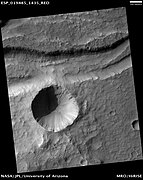
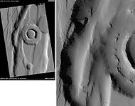 A ringed pit in the Tractus Fossae, as seen by HiRISE. Image is located in Tharsis quadrangle. Scale bar is 1000 m.
 -
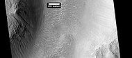
 The Ceraunius Fossae, as seen by HiRISE. Image is located in Tharsis quadrangle.
 -
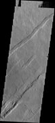
 The Olympica Fossae, as seen by HiRISE. Click on image to see rock layers in wall. Image is located in Tharsis quadrangle.


Arcadia quadrangle
-
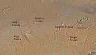 Map of Arcadia quadrangle with major features labeled. Several large fossae are indicated on the map
 -
 Graben near Alba Patera. Graben and catenae, collapse features, both caused by faults. When the crust is stretched, faults form and material falls into voids created by the stretching. Uranius Tholus (upper) and Ceraunius Tholus (largest) volcanoes are visible in wide context view, below and to the right of Alba Patera. Image is located in Arcadia quadrangle. Image taken with THEMIS
 -
 Forces from different directions caused this complex of grabens to form. Image is located in Arcadia quadrangle. Image taken with THEMIS
 -
 Mareotis Fossae Region, as seen by HiRISE. Image is located in Arcadia quadrangle
 -
 Tantalus Fossae, as seen by HiRISE. Click on image to see dust devil tracks. Image is located in Arcadia quadrangle


Elysium quadrangle
-
 Map of Elysium quadrangle. Elysium Mons and Albor Tholus are large volcanoes; locations of large fossae are indicated
 -
 The Cerberus Fossae in the Elysium quadrangle, as seen by HiRISE (scale bar is 1.0 km)
 -
 The Elysium Fossae in Elysium quadrangle, as seen by HiRISE (scale bar is 500 m)
 -
 Troughs to the east of Albor Tholus, as seen by HiRISE under the HiWish program.
 -
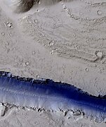 Portion of a trough (fossa) in Elysium Planitia, as seen by HiRISE under the HiWish program (blue indicates probably seasonal frost)


Mare Tyrrhenum quadrangle
-
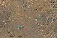 Map of Mare Tyrrhenum quadrangle. Tyrrhena Patera is a major volcano with pit craters.
 -
 Tyrrhena Patera, as seen by HiRISE and suggested by Ehsan Sanaei's high school astronomy club in Yazd, Iran. Click on image to see excellent view of pit crater chains and concentric features around a volcano.


Memnonia quadrangle
-
 Graben in Memnonia Fossae, as seen by HiRISE. This graben is believed to be the result of magmatic dikes rather than regional tectonic stretching. The scale bar is 1000 meters long.

Phoenicus Lacus quadrangle
-
 Oti Fossae in the Phoenicis Lacus quadrangle, as seen by HiRISE.
 -
 Oti Fossae, as seen by THEMIS. These parallel graben are found on the northeastern side of Arsia Mons; they are in line with the NE/SW trend of the three volcanoes in Tharsis.
 -
 Oti Fossae, as seen by THEMIS. These parallel graben are found on the northeastern side of Arsia Mons; they are in line with the NE/SW trend of the three volcanoes in Tharsis.


Diacria quadrangle
-
 Cyane Fossae in the Diacria quadrangle, as seen by HiRISE.

Phaethontis quadrangle
-
 Icaria Fossae Graben in the Phaethontis quadrangle, as seen by HiRISE. Click on image for a better view of Dust Devil Tracks.
 -
 MOLA context image for the series of three images to follow of gullies in a trough and nearby crater. This image shows where the image is in relation to Mariner Crater and Sirenum Fossae.
 -
 Gullies in a trough and nearby crater, as seen by HiRISE under the HiWish program. Scale bar is 500 meters long.
 -
 Close-up of gullies in trough, as seen by HiRISE under the HiWish program. These are some of the smaller gullies visible on Mars.


Ismenius Lacus quadrangle
-
 Coloe Fossae Dikes and/or faults, as seen by HiRISE. Dikes and faults may have produced mineral deposits. Coloe Fossae is in the Ismenius Lacus quadrangle.
 -
 Coloe Fossae lineated valley fill, as seen by HiRISE. Coloe Fossae is in the Ismenius Lacus quadrangle. Scale bar is 500 meters long.
 -
 Coloe Fossae Pits, as seen by HiRISE. Pits are believed to result from escaping water. Coloe Fossae is in the Ismenius Lacus quadrangle.


Cebrenia quadrangle
-
 Galaxias Fossae Trough, as seen by HiRISE. Image in the Cebrenia quadrangle.
 -
 Hephaestus Fossae: two views, as seen by HiRISE. Picture on right lies to the top (north) of other picture. Fossa (geology) often form by material moving into an underground void. Image located in Cebrenia quadrangle.


Lunae Palus quadrangle
-
 Labeatis Fossae, as seen by THEMIS. Labeatis Fossae is in the Lunae Palus quadrangle.
 -
 Close-up view of Labeatis Fossae, as seen by THEMIS. Labeatis Fossae is in the Lunae Palus quadrangle.


Amenthes quadrangle
-
 Wall of Amenthes Fossae, as seen by HiRISE under HiWish program.
 -
 Large pits, as seen by HiRISE under HiWish program
 -
 Trough, as seen by HiRISE under HiWish program
 -
Hephaestus Fossae Two Views, as seen by HiRISE. Picture on right lies to the top (north) of other picture. Fossa (geology) often form by material moving into an underground void.
-
 Troughs, as seen by HiRISE under HiWish program


References
- ^ Mars Art Gallery Martian Feature Name Nomenclature
- ^ Michael H. Carr (2006). The surface of Mars. Cambridge University Press. ISBN 978-0-521-87201-0. Retrieved 21 March 2011.
- ^ Anderson, Robert C.; Dohm, James M.; Golombek, Matthew P.; Haldemann, Albert F. C.; Franklin, Brenda J.; Tanaka, Kenneth L.; Lias, Juan; Peer, Brian (25 September 2001). "Primary centers and secondary concentrations of tectonic activity through time in the western hemisphere of Mars". Journal of Geophysical Research: Planets. 106 (E9): 20563–20585. Bibcode:2001JGR...10620563A. doi:10.1029/2000JE001278. ISSN 0148-0227.
- ^ Skinner, J. A.; Skinner, L. A.; Kargel, J. S. (March 12–16, 2007). Re-assessment of Hydrovolcanism-based Resurfacing within the Galaxias Fossae Region of Mars (PDF). 38th Annual Lunar and Planetary Science Conference. Lunar and Planetary Science. Vol. XXXVIII. League City, Texas. p. 1998. Bibcode:2007LPI....38.1998S.
- ^ HiRISE | Craters and Pit Crater Chains in Chryse Planitia (PSP_008641_2105)
- ^ a b Wyrick, D. Y.; Ferrill, D. A.; Sims, D. W.; Colton, S. L. (March 17–21, 2003). Distribution, Morphology and Structural Associations of Martian Pit Crater Chains (PDF). 34th Annual Lunar and Planetary Science Conference. Lunar and Planetary Science. Vol. XXXIV. League City, Texas. Bibcode:2003LPI....34.2025W.
- ^ HiRISE | Graben in Memnonia Fossae (PSP_005376_1575)
- ^ [1] [dead link]
- ^ Mars Global Surveyor MOC2-620 Release
- ^ Ferrill, David A.; Wyrick, Danielle Y.; Morris, Alan P.; Sims, Darrell W.; Franklin, Nathan M. (2004). "Dilational fault slip and pit chain formation on Mars". GSA Today. 14 (10): 4. Bibcode:2004GSAT...14j...4F. doi:10.1130/1052-5173(2004)014<4:dfsapc>2.0.co;2. ISSN 1052-5173.