
File:Bahrain International Circuit--Flat Oval.svg

Size of this PNG preview of this SVG file: 800 × 202 pixels. Other resolutions: 320 × 81 pixels | 640 × 162 pixels | 1,024 × 259 pixels | 1,280 × 323 pixels | 2,560 × 647 pixels | 1,243 × 314 pixels.
Original file (SVG file, nominally 1,243 × 314 pixels, file size: 29 KB)
| This is a file from the Wikimedia Commons. Information from its description page there is shown below. Commons is a freely licensed media file repository. You can help. |
Summary
| Description |
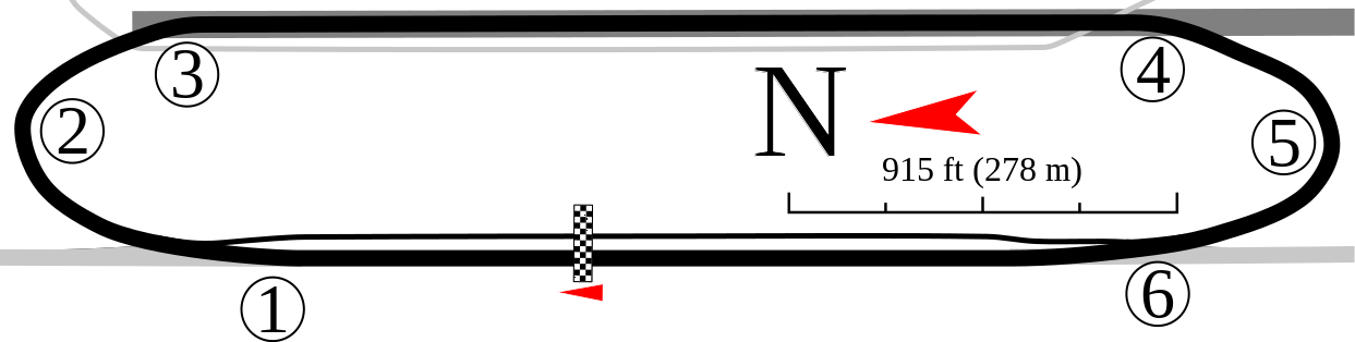
English: For use with Bahrain International Circuit. Shows the flat oval that can be seen in Google Earth. |
| Date | |
| Source | Own work |
| Author | Will Pittenger |
| Other versions |
Older files
Other versions of this particular image
|


This W3C-unspecified vector image was created with Inkscape .
| Camera location | | View this and other nearby images on: OpenStreetMap |
|---|
Licensing
I, the copyright holder of this work, hereby publish it under the following license:
This file is licensed under the Creative Commons Attribution-Share Alike 3.0 Unported license.
- You are free:
- to share – to copy, distribute and transmit the work
- to remix – to adapt the work
- Under the following conditions:
- attribution – You must give appropriate credit, provide a link to the license, and indicate if changes were made. You may do so in any reasonable manner, but not in any way that suggests the licensor endorses you or your use.
- share alike – If you remix, transform, or build upon the material, you must distribute your contributions under the same or compatible license as the original.
File history
Click on a date/time to view the file as it appeared at that time.
| Date/Time | Thumbnail | Dimensions | User | Comment | |
|---|---|---|---|---|---|
| current | 21:46, 16 March 2017 | 1,243 × 314 (29 KB) | Cherkash | removed incorrect metadata (circuit length, etc.) as doesn't belong to the image itself anyway | |
| 16:49, 13 January 2010 | 1,243 × 314 (30 KB) | Will Pittenger | {{Information |Description={{en|1=For use with w:Bahrain International Circuit. Shows the flat oval that can be seen in w:Google Earth.}} |Source={{own}} |Author=Will Pittenger |Date=2010-01-13 |Permission= |other_version |
File usage
The following pages on the English Wikipedia use this file (pages on other projects are not listed):
Global file usage
The following other wikis use this file:
- Usage on ar.wikipedia.org
- Usage on ast.wikipedia.org
- Usage on ca.wikipedia.org
- Usage on cs.wikipedia.org
- Usage on da.wikipedia.org
- Usage on es.wikipedia.org
- Usage on et.wikipedia.org
- Usage on fa.wikipedia.org
- Usage on fi.wikipedia.org
- Usage on fr.wikipedia.org
- Usage on gl.wikipedia.org
- Usage on he.wikipedia.org
- Usage on id.wikipedia.org
- Usage on it.wikipedia.org
- Usage on ja.wikipedia.org
- Usage on ms.wikipedia.org
- Usage on nl.wikipedia.org
- Usage on pt.wikipedia.org
- Usage on simple.wikipedia.org
- Usage on sk.wikipedia.org
- Usage on sl.wikipedia.org
- Usage on sv.wikipedia.org
- Usage on tr.wikipedia.org
- Usage on vi.wikipedia.org
- Usage on zh.wikipedia.org